


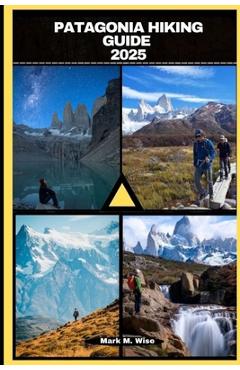
Los Glaciares National Park Map 1 Monte Fitz Roy & Cerro Torre, El Chalten, Lagos Viedma, O'Higgins & Del Desierto Trekking/Hiking/Walking Topographic
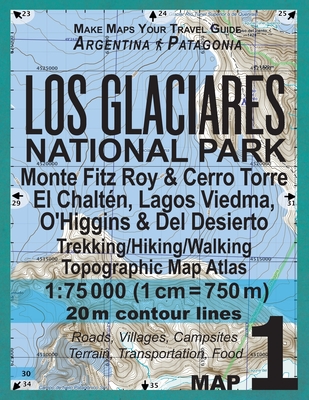
Los Glaciares National Park Map 1 Monte Fitz Roy & Cerro Torre, El Chalten, Lagos Viedma, O'Higgins & Del Desierto Trekking/Hiking/Walking Topographic
The map scale of 1:75000 (1 cm = 750 meters) provides a wide coverage of the area in good detail while keeping low the weight of the atlas itself. The large page format of 8.5x11in minimizes page count and along with the overlapping map design allows for comfortable navigation.
The details included in the topographic maps of this Atlas were specifically selected to be useful for trekkers, hikers and walkers of all interests, and make it easy to plan and enjoy both shortexcursions and hikes as well as long multi-day adventures along the main marked routes and/or adjacent trails and paths, which are alsoshown on the maps.
With this ultralight atlas you will always have a detailed, reliable, information-rich, battery-independent, shatter-proof map for youradventure.
Mercator projection SAD69 with both UTM and WGS84 coordinate grids.
PRP: 115.86 Lei
Acesta este Pretul Recomandat de Producator. Pretul de vanzare al produsului este afisat mai jos.
98.48Lei
98.48Lei
115.86 LeiPrimesti 98 puncte

Livrare in 2-4 saptamani
Descrierea produsului
The map scale of 1:75000 (1 cm = 750 meters) provides a wide coverage of the area in good detail while keeping low the weight of the atlas itself. The large page format of 8.5x11in minimizes page count and along with the overlapping map design allows for comfortable navigation.
The details included in the topographic maps of this Atlas were specifically selected to be useful for trekkers, hikers and walkers of all interests, and make it easy to plan and enjoy both shortexcursions and hikes as well as long multi-day adventures along the main marked routes and/or adjacent trails and paths, which are alsoshown on the maps.
With this ultralight atlas you will always have a detailed, reliable, information-rich, battery-independent, shatter-proof map for youradventure.
Mercator projection SAD69 with both UTM and WGS84 coordinate grids.
Detaliile produsului
S-ar putea sa-ti placa si
-
PRP: 185.69 Lei
157.84 Lei
157.84 Lei185.69 Lei
-

PRP: 136.34 Lei
115.89 Lei
115.89 Lei136.34 Lei
-

PRP: 154.92 Lei
131.68 Lei
131.68 Lei154.92 Lei
-

PRP: 79.36 Lei
67.46 Lei
67.46 Lei79.36 Lei
-
PRP: 136.40 Lei
115.94 Lei
115.94 Lei136.40 Lei
-

PRP: 173.54 Lei
147.51 Lei
147.51 Lei173.54 Lei
-
PRP: 107.57 Lei
91.43 Lei
91.43 Lei107.57 Lei
-
PRP: 116.25 Lei
98.81 Lei
98.81 Lei116.25 Lei
-
PRP: 46.42 Lei
39.46 Lei
39.46 Lei46.42 Lei
-

PRP: 167.34 Lei
142.24 Lei
142.24 Lei167.34 Lei
-

PRP: 161.14 Lei
136.97 Lei
136.97 Lei161.14 Lei
-

PRP: 184.06 Lei
156.45 Lei
156.45 Lei184.06 Lei
-

PRP: 77.42 Lei
65.81 Lei
65.81 Lei77.42 Lei
-

PRP: 173.60 Lei
147.56 Lei
147.56 Lei173.60 Lei
-
PRP: 123.69 Lei
105.14 Lei
105.14 Lei123.69 Lei
De acelasi autor
-

PRP: 115.86 Lei
98.48 Lei
98.48 Lei115.86 Lei
-
PRP: 115.86 Lei
98.48 Lei
98.48 Lei115.86 Lei
-
PRP: 115.86 Lei
98.48 Lei
98.48 Lei115.86 Lei
-
PRP: 115.86 Lei
98.48 Lei
98.48 Lei115.86 Lei
-
PRP: 115.86 Lei
98.48 Lei
98.48 Lei115.86 Lei
-
PRP: 115.86 Lei
98.48 Lei
98.48 Lei115.86 Lei
-
PRP: 115.86 Lei
98.48 Lei
98.48 Lei115.86 Lei
-
PRP: 115.86 Lei
98.48 Lei
98.48 Lei115.86 Lei
-
PRP: 115.86 Lei
98.48 Lei
98.48 Lei115.86 Lei
-
PRP: 115.86 Lei
98.48 Lei
98.48 Lei115.86 Lei
-
PRP: 115.86 Lei
98.48 Lei
98.48 Lei115.86 Lei
-
PRP: 115.86 Lei
98.48 Lei
98.48 Lei115.86 Lei
-
PRP: 115.86 Lei
98.48 Lei
98.48 Lei115.86 Lei
-
PRP: 115.86 Lei
98.48 Lei
98.48 Lei115.86 Lei


